
Lake Powell generates a steady stream of numbers — elevations, acre-feet, record dates — and most of them trace back to a handful of facts about how the reservoir was built and what it does. Here are 21 of them, each one sourced.
The short answer
Lake Powell is the second-largest reservoir in the United States: a 186-mile-long, 1,960-mile-shoreline pool holding about 25 million acre-feet at full pool behind the 710-foot Glen Canyon Dam. It exists to bank the Upper Colorado River Basin’s water, took 17 years to fill, peaked 8 feet above full in 1983, hit a modern low in April 2023, and fell below it in August 2026.
Quick stats
| Stat | Figure |
|---|---|
| Length at full pool | 186 miles |
| Shoreline at full pool | ~1,960 miles |
| Max depth at the dam (full pool) | ~560 ft |
| Capacity (2018 USGS survey) | 25.16 MAF |
| Dam height | 710 ft |
| All-time high | 3,708.34 ft (July 14, 1983) |
| Modern record low | Reset Aug 15, 2026; prior low 3,519.92 ft (April 13, 2023) |
The reservoir that took 17 years to fill
1. Lake Powell is a reservoir, made by a dam
Before 1963 there was a free-flowing Colorado River at the bottom of Glen Canyon. When Glen Canyon Dam’s diversion gates closed on March 13, 1963, the river began backing up into the sandstone canyons of the Utah–Arizona border, and Lake Powell was born (U.S. Bureau of Reclamation).
2. It’s named for a one-armed river explorer
The reservoir honors Major John Wesley Powell, who led the first scientific expedition down the Green and Colorado Rivers in 1869 and ran the canyons again in 1871–72 (USGS). Powell named Glen Canyon itself — the canyon his namesake lake later covered.
3. Page, Arizona exists because of the dam
The town of Page began in 1957 as a construction camp for the thousands of workers who built Glen Canyon Dam (USBR, Glen Canyon Unit). The dam came first; the town, the bridge, and the highway followed.
4. Filling it took 17 years
Drought in the mid-1960s and the obligation to keep water moving downstream stretched the fill across nearly two decades. The lake finally touched its full-pool elevation of 3,700 feet on June 22, 1980 (USBR).
5. It flooded one of the Southwest’s great canyons
Glen Canyon held cathedral-sized alcoves, ancestral Puebloan sites, and historic river crossings. Nearly all of it went under as the reservoir rose — the full inventory is in what’s under Lake Powell.
How big it really is
6. It stretches 186 miles
At full pool the reservoir runs 186 miles up the Colorado River from Glen Canyon Dam, reaching almost to Hite, Utah (USBR brochure, PDF).
7. Its shoreline is about 1,960 miles
All those flooded side canyons add up: at full pool the shoreline measures roughly 1,960 miles (USBR). The shoreline shrinks and grows as the level moves — one reason low water strands boat ramps.
8. The water is about 560 feet deep at the dam — when full
At full pool, roughly 560 feet of water stands against Glen Canyon Dam, where the old river channel sits near 3,130 feet above sea level. Depth follows the surface, so the lake is much shallower than that today — how deep is Lake Powell has the arithmetic.
9. It holds 25.16 million acre-feet — per the 2018 survey
The first complete resurvey since 1986 put full-pool capacity at 25,160,000 acre-feet (USGS SIR 2022-5017). The older operational figure of about 24.3 MAF still anchors Reclamation’s “percent full” math — how much water is in Lake Powell untangles the two.
10. Only Lake Mead is bigger
Lake Powell is the second-largest reservoir in the United States by capacity. Lake Mead, its downstream twin behind Hoover Dam, holds about 26 MAF at capacity today — sediment has trimmed it from its original 28.9 (USBR). The two reservoirs rise and fall together — the Powell vs. Mead comparison tracks both live.
11. Glen Canyon Dam is 710 feet tall — 16 feet shy of Hoover
The dam stands 710 feet above bedrock, just short of Hoover Dam’s 726 (USBR). The two are close cousins in size but different machines in purpose — see Glen Canyon Dam vs. Hoover Dam.
12. Its power plant can light millions of homes
Eight generators with 1,320 megawatts of installed capacity supply wholesale power that reaches roughly 5 million customers across seven Western states (USBR). That’s why the 3,490-foot minimum power pool line matters so much.
The water itself
13. The lake is the Upper Basin’s savings account
Under the 1922 Colorado River Compact, the Upper Basin must not deplete the river below 75 million acre-feet at Lee Ferry over any ten consecutive years (Law of the River, USBR). Lake Powell banks wet-year water so that delivery holds in dry years — that is its job.
14. Four rivers feed it
The Colorado supplies most of the inflow, joined by the San Juan, the Escalante, and the Dirty Devil (NPS Glen Canyon brochure, PDF). Where that water starts — as Rocky Mountain snow — is covered in where Lake Powell gets its water.
15. The water leaves the dam cold
Releases draw from deep in the reservoir, so the river below the dam runs cold year-round — typically in the mid-40s to mid-50s °F at Lees Ferry, per USGS monitoring. That cold, clear water supports the famous trout tailwater downstream.
16. Sediment is slowly filling it
The Colorado carries the canyon country with it. Between 1963 and 2018, Lake Powell lost 6.79% of its storage capacity to sediment — an average of about 33,000 acre-feet a year (USGS).
17. Surface temperatures swing about 35 degrees a year
The lake’s surface runs from the mid-40s °F in winter to the low 80s in high summer. This site tracks it by satellite, daily, on the water temperature page.
Records and the drought era
18. Its record high nearly broke the dam
On July 14, 1983, the lake crested at 3,708.34 feet — 8 feet above full pool — while a flood forced the spillways to run. Cavitation gutted the spillway tunnels, and crews bolted plywood flashboards atop the gates to buy time (The Colorado Sun).
19. Its record low came 40 years later, then fell again in 2026
On April 13, 2023, the lake bottomed at 3,519.92 feet, about 22% of capacity (NASA Earth Observatory) — around 188 feet below the 1983 high. That record lasted until August 15, 2026, when the lake fell below it; the callout above carries the running mark. All seven record marks are in Lake Powell’s water-level records.
20. It hasn’t been full since the 1980s
Reclamation last logged the lake as essentially full — 3,698.5 feet, 99% — on June 25, 1987 (USBR 1987 AOP, PDF). It came near full once more around 1999, then the drought era began. When was Lake Powell last full tells that story.
21. Roughly 2,000 archaeological sites lie beneath it
Before the water rose, the Glen Canyon Archaeological Salvage Project raced to document the canyon’s human record — about 2,000 sites in what is now Glen Canyon National Recreation Area, from ancestral Puebloan granaries to historic mining camps (Museum of Northern Arizona). For those sites, the survey notes are the final record.
Where the facts meet today’s water
Most of these numbers are fixed. The one that moves — today’s elevation — is in the live callout above, re-checked daily against the USBR record. To see how the current level stacks up against the 186 miles, the 560 feet, and the record marks, start with the water level chart and the dead pool tracker.
Sources
- U.S. Bureau of Reclamation — Glen Canyon Unit and Glen Canyon Dam brochure (PDF) (dimensions, power plant, fill history)
- U.S. Geological Survey — 2018 bathymetric survey, SIR 2022-5017 and news release (25.16 MAF capacity; 6.79% sediment loss)
- U.S. Geological Survey — Lake Powell before/after (John Wesley Powell naming) and Lees Ferry gage 09380000 (release temperatures)
- U.S. Bureau of Reclamation — Law of the River (1922 Compact delivery obligation) and Hoover Dam FAQs (Lake Mead comparison)
- NASA Earth Observatory — Lake Powell Rebounds but Drought Remains (2023 record low, ~22% capacity)
- Museum of Northern Arizona — Glen Canyon collections (~2,000 documented sites)
- National Park Service — Glen Canyon NRA brochure (PDF) (tributaries)
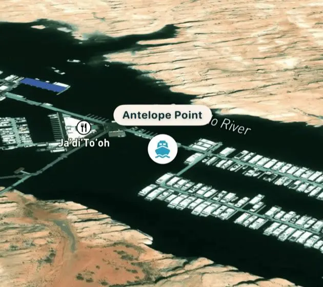
Hero photo: Lake Powell aerial view of Glen Canyon Dam, Wahweap Marina, and Page by Reinhard Link, licensed CC BY-SA 2.0, via Wikimedia Commons (cropped).

,_Wahweap_Marina_(center_top),_the_town_of_Page_(center_down)_and_on_the_left_Colorado_River_downstream_towards_Grand_Canyon_(50294961102).jpg)