
Lake Powell is the water you see. Under it sits Glen Canyon — a place explorers compared to a sandstone cathedral, flooded between 1963 and 1980 and only occasionally, partially, given back. What’s visible in any given year comes down to one number: the elevation of the lake surface.
The short answer
When Glen Canyon Dam’s gates closed in 1963, the rising reservoir drowned a 186-mile canyon system: named wonders like Cathedral in the Desert, Music Temple, and Gregory Natural Bridge; the 1776 Crossing of the Fathers; the river town of Hite; a failed gold dredge; and roughly 2,000 documented archaeological sites. Some of it re-emerges when drought pulls the lake down. Most of it stays under hundreds of feet of water.
The drowned inventory, by depth
| Feature | What it was | Approx. elevation | At the 2023 low (3,519.92 ft) |
|---|---|---|---|
| Cathedral in the Desert | Sandstone alcove chamber | floor ~3,575 ft | Fully exposed |
| Gregory Natural Bridge | 137-ft natural bridge | arch base ~3,543 ft | Arch above water |
| Town of Hite / Dandy Crossing | 1880s river settlement and ford | upper-lake river level | Area largely exposed |
| Music Temple | Echoing alcove Powell named in 1869 | mid-canyon river level | Mostly submerged |
| Hoskaninni gold dredge | 1900s mining machine | river channel | Submerged |
| Crossing of the Fathers | 1776 river ford | ~3,180 ft | Under ~340 ft of water |
| ~2,000 archaeological sites | Ancestral Puebloan and historic sites | varies widely | Mixed |
Elevations are approximate — drawn from the sources below, not survey data. The water level chart shows where the surface sits today against these marks.
1. Glen Canyon itself
The reservoir’s namesake is also its biggest casualty. Glen Canyon ran 186 miles from near Hite down to the dam site, a corridor of alcoves, hanging gardens, and side canyons that John Wesley Powell named on his 1869 expedition. The Glen Canyon Archaeological Salvage Project surveyed it through the late 1950s and early 1960s precisely because the water was coming; for much of the canyon, those reports and photographs are what remains (University of Utah / NPS archive).
2. Cathedral in the Desert
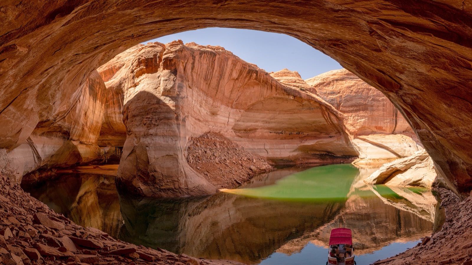
The most famous drowned chamber in the canyon — an enormous alcove in Clear Creek Canyon off the Escalante arm, with a waterfall dropping through a slot in its ceiling. The Glen Canyon Institute tracks its re-emergence by elevation: the alcove starts to appear below about 3,605 feet, the waterfall flows below about 3,580 feet, and near 3,575 feet you can stand on its floor. During the 2022–2023 lows, the whole chamber stood out of the water — floored by decades of reservoir sediment rather than the original streambed.
3. Music Temple
Powell’s 1869 crew rested in a vaulted alcove near the San Juan confluence whose acoustics moved them to sing hymns in it; Powell named it Music Temple. It sat low along the main channel, and the reservoir covered it as the lake filled. Unlike Cathedral in the Desert, it has stayed mostly under water even through the recent drought lows — its floor sits too deep for the modern lake to hand back.
4. Gregory Natural Bridge
A 137-foot sandstone bridge in Fiftymile Creek Canyon, off the Escalante arm — big enough that it ranked among the largest natural bridges in the country before the flood. It went under as the lake rose and, per Atlas Obscura, went unseen from 1969 until falling water brought it back into view in the 2020s. Boaters tracked its clearance by the foot: passage under the arch was tied to lake elevations around 3,543 feet (Wayne’s Words advisory).
5. The Crossing of the Fathers
In November 1776, the Dominguez–Escalante expedition — trying to get home to Santa Fe — found one of the only fordable spots on the Colorado for a hundred miles and cut steps down to it. The crossing sits near 3,180 feet above sea level, now under Padre Bay, which takes its name from the friars (Crossing of the Fathers). This one is never coming back on any realistic timeline: even at the 2023 low, about 340 feet of water covered it, and at full pool the figure is roughly 520 feet.
6. Roughly 2,000 archaeological sites
Ancestral Puebloan and Fremont people farmed benches and built granaries, dwellings, and rock art panels throughout Glen Canyon. Ahead of the flood, the University of Utah and the Museum of Northern Arizona split the canyon and raced to record it — the Glen Canyon Archaeological Salvage Project, one of the largest such efforts ever mounted in the Southwest. About 2,000 sites are known across what is now Glen Canyon National Recreation Area (Museum of Northern Arizona), and for the sites the water took, the survey sheets became the final record (University of Utah Anthropological Papers). When low water re-exposes sites, they’re fragile — the NPS asks visitors not to touch walls or rock art (NPS preservation guidance).
7. Hite and the Dandy Crossing
Prospector Cass Hite showed up in 1880 chasing gold and found something more useful: a natural ford he called the Dandy Crossing. The small settlement of Hite grew beside it — post office, ferry, a handful of buildings serving miners and travelers in some of the most remote country in the lower 48. The rising reservoir drowned the town site in the 1960s (Hite, Utah); the modern Hite area on the upper lake sits on higher ground nearby. At the drought-era lows, the upper reservoir receded enough to turn much of that reach back into a river.
8. Fort Moqui
Near Hite stood a stone structure that gold-rush miners nicknamed Fort Moqui — a thousand-year-old ancestral Puebloan building they read, wrongly, as a fort (Canyon Country Zephyr). It was photographed and recorded before the reservoir reached it and slipped under with the rest of the upper canyon. Like the town beside it, its remains sit in the zone the lake alternately covers and exposes as the level swings.
9. The Hoskaninni gold dredge
Glen Canyon’s gold rush ended in one of the West’s great engineering flops. Around 1900, engineer Robert Brewster Stanton convinced investors to fund a 46-bucket dredge for the Hoskaninni Company to mine the river’s gravel bars; the gold proved too fine to recover, and the venture collapsed within about a year (Hoskaninni Papers, C. Gregory Crampton). The abandoned dredge sat in the river channel for decades — river runners used to visit the wreck — until the reservoir buried it.
Which landmarks sit above water at today’s elevation
Every one of these places has an elevation, and the lake’s daily reading puts it above or below the waterline. Glen Canyon’s re-emergence is a ladder, rung by rung, foot by foot. The 2021–2023 drought lows handed back Cathedral in the Desert and Gregory Natural Bridge; a wetter run of years would take them again; the Crossing of the Fathers stays down regardless.
The water level chart tracks the surface against that ladder daily, and how low is Lake Powell puts today’s level in context. For the longer arc — how the reservoir filled over Glen Canyon in the first place and how the drought has walked it back down — see Lake Powell’s water level history and the dead pool tracker.
Sources
- Glen Canyon Institute — A Journey to Cathedral in the Desert (re-emergence elevation thresholds)
- Museum of Northern Arizona — Glen Canyon collections (~2,000 documented sites; salvage project role)
- University of Utah Anthropological Papers via NPS — Glen Canyon: A Summary and survey methodology
- National Park Service — Glen Canyon NRA preservation guidance
- Atlas Obscura — Gregory Natural Bridge; Wayne’s Words — boating advisory (clearance elevations)
- C. Gregory Crampton — The Hoskaninni Papers (PDF) (Stanton dredge)
- Wikipedia — Crossing of the Fathers and Hite, Utah (locations and elevations)
- Canyon Country Zephyr — The Resurrection of Fort Moki
Hero photo: Cathedral in the Desert by Jay Huang, licensed CC BY 2.0, via Wikimedia Commons (cropped).