
The Colorado River is a mid-sized river doing an outsized job. It carries a fraction of the Mississippi’s flow, yet it supplies two of the largest reservoirs in the country, seven states, and Mexico. These 15 facts, each sourced to Reclamation, USGS, NPS, or peer-reviewed research, explain how a river this small became this important, and why it’s running short.
The short answer
The Colorado River runs about 1,450 miles from the Rocky Mountains toward the Gulf of California and supplies roughly 40 million people. A 1922 compact split 15 million acre-feet a year between its Upper and Lower Basins, but since 2000 the river’s natural flow has averaged 12.3 million acre-feet. Two reservoirs, Lake Powell and Lake Mead, hold about 85% of the system’s storage, and both sit far below full pool.
The river in numbers
| Fact | Figure | Source |
|---|---|---|
| Length | ~1,450 miles | USBR / USGS |
| Drainage basin | ~250,000 sq mi, 7 states + Mexico | USBR |
| People served | ~40 million | USBR Final EIS (2026) |
| Irrigated land | ~5.5 million acres | USBR Final EIS (2026) |
| Natural flow at Lees Ferry, 1906–2025 | 14.6 MAF/yr | USBR Final EIS (2026) |
| Natural flow at Lees Ferry, 2000–2025 | 12.3 MAF/yr | USBR Final EIS (2026) |
| 1922 Compact apportionment | 7.5 MAF Upper + 7.5 MAF Lower | Colorado River Compact |
| System storage | ~60 MAF, ~85% in Powell + Mead | USBR Final EIS (2026) |
1. It runs about 1,450 miles and drains a quarter-million square miles
The Colorado rises in Rocky Mountain National Park and ends, when it ends at all, in the Gulf of California. The U.S. Bureau of Reclamation puts the basin at roughly 250,000 square miles across Arizona, California, Colorado, Nevada, New Mexico, Utah, and Wyoming, and the river at about 1,400 miles. The U.S. Geological Survey measures it at 1,440 miles and ranks it sixth among the 135 U.S. rivers longer than 100 miles.
2. It was the Grand River until 1921
For most of the 19th century, the stream that starts in Colorado was the Grand River, and the name “Colorado” applied only below its junction with the Green in Utah. Congress applied the name Colorado to the entire river in 1921 (USGS), after the state of Colorado pushed to have the river carry its name from the source. The Grand survives in Grand Junction, Grand Lake, and Grand Valley.
3. Its longest tributary, the Green, is 730 miles long on its own
The Green River runs 730 miles from its headwaters in Wyoming to its confluence with the Colorado in Canyonlands, Utah (National Park Service), which makes it the longest tributary in the Colorado system. Its own largest tributary, the Yampa, is the last major free-flowing river in that system. Where all that water starts is mapped in where Lake Powell gets its water.
4. About 85% of the flow comes from 15% of the land
The Colorado is a snowmelt river. Winter snow and spring melt from the high mountains that make up about 15% of the Upper Basin’s area produce about 85% of the river’s annual flow (USGS Circular 1502). Reclamation’s 2026 Final EIS adds the reason: those mountain rims average more than 40 inches of precipitation a year, while most of the basin is arid or semi-arid and gets less than 20.
5. It supplies roughly 40 million people and 5.5 million irrigated acres
Reclamation’s Post-2026 Final Environmental Impact Statement (July 2026) states the river provides water to approximately 40 million people and nearly 5.5 million acres of agricultural land. About 70% of the water goes to agriculture (USBR).
6. The 1922 Compact divided more water than the river delivers
The Colorado River Compact apportioned 7.5 million acre-feet a year to the Upper Basin and 7.5 million to the Lower Basin, and it bars the Upper Division states from depleting the flow at Lee Ferry below 75 million acre-feet in any 10 consecutive years (USBR Final EIS, Ch. 1). The negotiators worked from a wet stretch of the early 20th century. The same Reclamation document puts the average natural flow at Lees Ferry at 14.6 million acre-feet a year for 1906–2025, and 12.3 million for 2000–2025. That gap between paper water and wet water is the structural deficit behind why Lake Powell is so low.
7. Mexico is guaranteed 1.5 million acre-feet a year
The 1944 U.S.–Mexico Water Treaty guarantees Mexico 1.5 million acre-feet of Colorado River water each year, delivered on schedules Mexico sets in advance, with proportional cuts allowed only in extraordinary drought (International Boundary and Water Commission). Add that to the two basins’ 15 million and the river is committed to 16.5 million acre-feet a year, before evaporation. Against a 21st-century natural flow of 12.3 million, the arithmetic doesn’t close.
8. Two reservoirs hold about 85% of the system’s storage
The Colorado River system can store approximately 60 million acre-feet, roughly four years of the river’s average flow, and Lake Powell and Lake Mead provide about 85% of it (USBR Final EIS, Ch. 1). That concentration is why anyone tracking the river watches two elevations. The Lake Powell vs. Lake Mead page tracks both live, and Colorado River reservoirs walks the rest of the chain, from Flaming Gorge to Havasu.
9. Hoover and Glen Canyon are the two dams that run the river
Hoover Dam, finished in 1936, stands 726 feet above bedrock and created Lake Mead (USBR). Glen Canyon Dam, 710 feet tall, closed its diversion tunnels in March 1963 and created Lake Powell (USBR). Hoover delivers water to the Lower Basin and Mexico; Glen Canyon banks the Upper Basin’s share so it can meet the Compact’s 75-million-acre-foot obligation in dry years. The dam-by-dam comparison covers what each one does.
10. The river carved the Grand Canyon in about 5 to 6 million years
The Colorado began cutting downward through the Colorado Plateau 5 to 6 million years ago, according to the National Park Service, and today the river near Phantom Ranch runs about 2,400 feet above sea level, roughly a mile below the rims. The rock it exposes is far older: the oldest layers at the bottom are about 1.8 billion years old, and the Kaibab Formation at the top is 270 million.
11. The lower river evaporates roughly 860,000 acre-feet a year
Open water in the desert loses a lot to the sky. Reclamation’s Lower Colorado River evaporation study estimates average evaporation from Lake Mead to the Mexican border at about 860,000 acre-feet a year for 2017–2021, and total system losses, including riparian plants, at about 1.3 million acre-feet. Those losses are one reason a “Fill Mead First” proposal to consolidate storage in one reservoir keeps resurfacing.
12. Glen Canyon Dam cut the sediment at Lees Ferry by more than 99%
Before the dam, the Colorado ran red with the canyon country it was carrying. The USGS measured an annual suspended-sediment load at Lees Ferry of 65.4 million tons in 1948–1962; after Glen Canyon Dam began trapping it, the load fell to an estimated 0.4 million tons in 1982–1986 (USGS Open-File Report 93-174). That sediment now settles in Lake Powell instead, which lost 6.79% of its storage capacity to it between 1963 and 2018 (USGS).
13. Warming alone takes roughly 9% of the flow per degree Celsius
Two peer-reviewed findings frame the drought. Milly and Dunne, writing in Science in 2020, estimated the Colorado’s annual discharge falls about 9.3% for every 1 °C of warming, largely because shrinking snow cover exposes dark ground that absorbs sunlight and drives evaporation. Williams, Cook, and Smerdon found in Nature Climate Change (2022) that 2000–2021 was the driest 22-year period in southwestern North America since at least the year 800, and that human-caused warming made it substantially worse.
14. It rarely reaches the sea, and did so on purpose in 2014
With nearly all of its flow stored and consumed upstream, the Colorado has seldom reached the Gulf of California since the big 20th-century dams and diversions went in, apart from occasional flood years. In spring 2014, under Minute 319 of the 1944 treaty, the U.S. and Mexico released about 105,000 acre-feet from Morelos Dam as a deliberate “pulse flow” that began on March 23 and reconnected the river with the sea on May 15 (IBWC). The USGS, which tracked the event by satellite, reported it was the first time in 13 years that river water had reached the Gulf (USGS EROS).
15. The shortage era began in 2021 and deepened in 2027
Reclamation declared the first-ever Lower Basin shortage on August 16, 2021, cutting Arizona’s 2022 supply by 512,000 acre-feet (USBR). A year later it declared a Level 2a shortage for 2023, with Arizona’s cut rising to 592,000 acre-feet, about 21% of its apportionment (USBR). On August 21, 2026, the Interior Department finalized new 2027–2028 Operating Guidelines that provide for 1.25 million acre-feet of Lower Basin reductions in each of 2027 and 2028 (Arizona 760,000, California 440,000, and Nevada 50,000 under the three states’ proposed sharing plan) and set an expected Lake Powell release of 6.0 to 7.0 million acre-feet for water year 2027, with the final volume decided in April (USBR).
Where the river stands now
The 2007 Interim Guidelines that coordinated Powell and Mead for nearly two decades expire at the end of 2026. Interior’s August 2026 Record of Decision replaces them with a 10-year decision framework for 2027–2036, starting with operating guidelines for 2027 and 2028 and leaving room for a consensus deal among the seven states (USBR Post-2026).
On the ground, Lake Powell dropped below its April 2023 modern low of 3,519.92 feet on August 15, 2026, per the USBR daily record on the water level chart. The live callout above carries today’s elevation and the running record, and the dead pool tracker shows how much cushion remains above the 3,490-foot minimum power pool and the 3,370-foot dead pool. Whether the next winter changes any of that is the subject of the forecast page.
Sources
- U.S. Bureau of Reclamation — Colorado River Basin (basin area, seven states, 35–40 million people, 70% agriculture)
- U.S. Bureau of Reclamation — Post-2026 Final EIS, Chapter 1: Purpose and Need (PDF, July 2026) (40 million people, 5.5 million acres, Compact apportionments, natural flow 14.6 / 12.3 MAF, ~60 MAF storage, 85% in Powell and Mead)
- U.S. Bureau of Reclamation — Interior Department Finalizes Plans for 2027–2028 Colorado River Operations (August 21, 2026: 1.25 MAF Lower Basin reductions, expected Powell release 6.0–7.0 MAF) and Post-2026 Operations
- U.S. Bureau of Reclamation — 2022 operating conditions (first shortage) and 2023 operating conditions (Level 2a)
- U.S. Bureau of Reclamation — Lower Colorado River evaporation and system loss report (860 kAF evaporation, 2017–2021)
- U.S. Bureau of Reclamation — Hoover Dam FAQs and Glen Canyon Dam brochure (PDF) (dam heights and dates)
- U.S. Geological Survey — The Colorado River (General Interest Publication, PDF) (1,440 miles, sixth-longest, 1921 naming), Circular 1502 (85% of flow from 15% of area), Open-File Report 93-174 (sediment at Lees Ferry), 2018 Lake Powell resurvey (6.79% capacity loss), and EROS: delta response to the Minute 319 pulse flow
- National Park Service — Grand Canyon geology (5–6 million years, rock ages) and Dinosaur National Monument rivers (Green River, 730 miles; Yampa)
- International Boundary and Water Commission — 1944 Water Treaty (1.5 MAF to Mexico) and Minute 319 fact sheet (PDF) (2014 pulse flow)
- Milly & Dunne, “Colorado River flow dwindles as warming-driven loss of reflective snow energizes evaporation,” Science (2020)
- Williams, Cook & Smerdon, “Rapid intensification of the emerging southwestern North American megadrought in 2020–2021,” Nature Climate Change (2022)
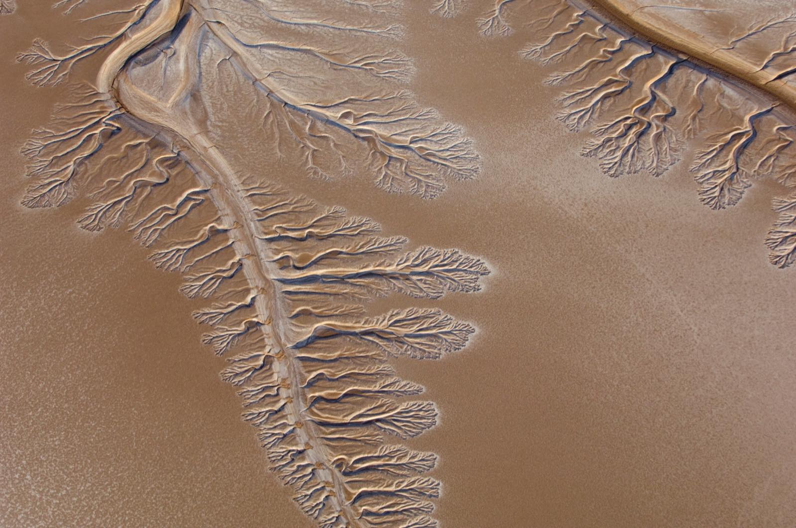
Hero photo: Colorado River Dry Delta by Pete McBride, U.S. Geological Survey, public domain per the USGS Multimedia Gallery, via Wikimedia Commons (cropped). It shows the river’s dry terminus in Sonora and Baja California in January 2009, about 5 miles short of the Gulf of California.